Friday, 21 July 2017

Thursday 20th July 2017 – Horsely, England

The campsite is, in theory, only 25 minutes from Calais port but we immediately found that we had to make a diversion to get around a ‘route barreé’, one of many that we have made during this holiday. Unfortunately, there was no signed diversion so we had to let the satnav guide us down some rather narrow lanes.
Security was very tight at the port with armed police and army on duty and many vehicles were stopped to be searched for illegal immigrants but, fortunately, we were not. The checks took longer than normal and certainly longer than at Dover but we were still in plenty of time for the ferry. We were more than 10 minutes late leaving and spent the crossing racing the DFDS ferry that was supposed to leave 10 minutes after us but left before us. We lost. We then had the longest ever wait to get off the ferry and must have been one of the very last vehicles off. Good job that we weren’t in a hurry.
We stopped at the Maidstone services on the M20 and just managed to squeeze into the area reserved for caravans and motorhomes. Many of the places were taken by cars and we saw a number of motorhomes and caravans that had to either leave without stopping or park in inappropriate places in the car park. A parking enforcement man walked passed me and I pointed out the problem. His job was to check that people were paying a charge if they were there for more than two hours but he said that the management were aware of the problem and had plans to do something about it – we will see! Much better signage is needed as I am sure that many of the car drivers probably didn’t realise that the spaces were for caravans.
As always, the motorways were very busy but the journey was uneventful and we were soon at the East Horsley campsite.
That is the end of this sojourn. We are spending a few days here to visit our son, daughter-in-law and grandson. On Sunday we are meeting friends at Lords to see the Women’s Cricket World Cup Final. We were lucky to get tickets early (it is now a sell-out) and were delighted to hear that England have made it through to the final. We are really looking forward to watching the match from the recently refurbished Warner’s Stand. Come On England!
We thoroughly enjoyed our trip around Denmark. It is a lovely country, the people are very friendly (everyone speaks English) and the archaeology and its presentation is first class. If you are thinking of a visit to Denmark, we thoroughly recommend it. Just be aware that, with a few exceptions such as public transport and fuel, the cost of living is very high.

Have fun!

Thursday, 20 July 2017

Wednesday 19th July 2017 – Ardres, France

Our route today started with hills and lovely wooded valleys but passing by Dinant, Philippeville and Chimay we crossed the border into France and the land became flatter and less interesting. We have seen many styles of churches on our travels and either side of the border we saw large, pretty churches with ornate steeples that often seemed too large for the communities that they served. Also the small roadside chapels started to make an appearance.
We reached the E44 at Le Cateau–Cambresis and, although this is a major road, progress can be slow due to the large number of villages with 50 km/hr speed limits.
The weather was, again, very sticky with temperatures hitting 31°C, even higher than yesterday. Unlike yesterday’s continuous heat, today the thunderstorms hit. The first was spectacular with huge amounts of lightning, extremely heavy rain and then hailstones. The temperature was 28°C before the storm and 16°C when it finished. There were a couple more storms later in the day but with little lightning and no hail.
We were heading for the Le Bien Assise at Guines, a large campsite close to Calais that we had used a few times in the past. However, we looked out for smaller campsites as we approached Calais and as we drove through Ardres we saw a sign and followed it. Camping Ardresien is only 25 minutes from Calais port and is a very tidy site. There are only two motorhome pitches but both were available so we chose one with their fishing lake directly behind.
After dinner we went for a walk through the site, which is mostly permanent or seasonal pitches, and found that there was an exit at the back. This took us onto a road and to more, larger lakes and another campsite. It turned out that there was a connection with our area of the Somerset Levels. The lakes had been created by the extraction of peat but this had finished in the 19th century, much earlier than the Somerset Levels where a small amount of extraction still continues.
We have noted Camping Ardresien (open April to September) and Camping du Café du Lac (open April to October) to our list for potential stopping places on future visits.

Photos: We passed this chateau at Leignon in Belgium; We knew that we were in a French campsite when we saw that our pitch was next to the Aire de Petanque; The lake behind our pitch; The café at Camping du Café du Lac with its larger lake; An even larger lake further down the road with more still in the distance.


Tuesday 18th July 2017 – Hamoir, Belgium

Soon after we started our journey today we saw something that we haven’t seen during the whole sojourn, serious hills. The scenery was almost alpine, with deep valleys and steep, high, wooded hillsides but without the peaks. We followed the minor B255 road down to the E35 motorway before changing to the E44 to cross the Rhine above Koblenz. Finally we took the E45 north and fell off the end near Prum. All of that motorway driving was trouble free. We didn’t go through any major urban areas, there was little traffic, the scenery was lovely and the driving was easy – ideal. Stopping for a late lunch at a convenient picnic spot with a good view, we opened up all windows in the van. At nearly 30°C, it was too hot to sit in the sun at the picnic table provided. The scenery was less dramatic now as we headed for the Belgium border, through a German speaking part of Belgium to the aire at Malmedy. Just a few miles from Malmedy, we came to a roadblock. We have come across many planned closed roads on this holiday and there was always a signed diversion. This time however, there was obviously an incident and it was the police who had closed the road, without any signed diversion. We headed off on many very minor rural roads, having to go onto the verge whenever a car came the other way. This is where the satnav comes into its own and we gradually made our way back to the main road just where a policeman was stopping cars at the other end of the road closure. When we arrived at Malmedy, we discovered that there wasn’t an aire! Our aire guide that covers Germany and Belgium is from 2011 and we knew that we ran the risk of finding an aire closed. In this case, they had built a whole row of shops at the old railway station where the aire used to be. There weren’t many options nearby but Hamoir was in the direction that we would be travelling tomorrow and was only 50 minutes away, so we headed there. After a false alarm when we thought that we had another fair in the parking place, we found the very large aire by the tennis courts, next to the river with good dumping and water facilities. We were very happy to pay the €8 fee for 24 hours. The temperature had dropped to 28°C, we were frazzled and didn’t fancy cooking, heating the van up even more. What’s more, we really liked the idea of a nice Belgium meal. We found a restaurant with a fixed menu for €35 and it was extremely good. At the end of three course and excellent house wine, we were stuffed! We had eaten at an outside table and it was still very warm. We returned to a very hot Henrietta, despite having parked her under the shade of a tree.

Photos: A stretch of the river Ourthe in Hamoir close to the aire; Presentation is half the art – they looked lovely and tasted great – Jane’s melon and Palma ham with sorbet and eau de vie and my goat’s cheese with apple and lardons.


Tuesday, 18 July 2017

Monday 17th July 2017 – Frankenberg, Germany

Yesterday’s long drive has given us the opportunity to take it easy for the next couple of days, setting a route for interest rather than speed. Our maps show in green areas of nature parks and wooded areas and they also show picturesque roads by a green line. We found the Weser Valley, a green road and plotted a route through green areas. We were rewarded with quiet roads, avenues of trees, beautiful countryside and pretty villages with timber-framed buildings. Below Hameln, the valley became very attractive with lovely views of the wide river. However it was lunchtime and we looked for a parking place with a view – there were plenty of parking places, often with picnic tables and every one of them had trees between it and the river, obscuring the view totally. We gave up and stopped at a very pleasant picnic area and looked at the trees.
In the middle section of the valley, the scenery was not as interesting so we headed west up a pretty valley before winding our way down to Frankenberg. There we drove to the aire, just on the edge of the old town and in view if the impressive spire of the church on the hill. We walked up into the town and tried to find a typical German restaurant. We found one, the menu was good and the door was open but it was closed on Mondays. We settled for an Italian restaurant where we had an excellent meal.

Photos: We spotted this lovely watermill (Langut Walkemuhle), now a restaurant and event centre, on the outskirts of Frankenberg; The Frankenberg Rathaus; One of the many timber-framed buildings in Frankenberg.


Monday, 17 July 2017

Sunday 16th July 2017 - Hodenhagen, Germany

If yesterday’s weather was glorious, today’s was the opposite (inglorious??). Light rain started at 07:30 and got heavier over breakfast.
We came to Sorro because we wanted to visit Trelleborg, the best preserved of Harald Bluetooth’s ring forts where a large Viking market is being held at the moment. We drove there through the persistent rain and it was still raining when we arrived. Entrance to the site and the museum is normally free but during the Viking market the charge is approx. £14 a head. We thought hard about it but couldn’t justify paying £28 to get absolutely soaked. We had seen three other ring forts and two Viking markets and so, reluctantly, we decided to move on. There was nothing special happening in the market today but later in the week they stage battles with hundreds of Vikings taking part. The weather forecast for later in the week is dry and sunny, so they should have a good time.
On the way to Denmark we had a horrible journey on the motorways in temperatures up in the 30’s. The forecast is that the temperatures are going to reach 30 over the next few days. Our earlier than expected departure meant that we could do what we normally do on our sojourns, potter along smaller roads and find an aire in a nice location.
We crossed that very expensive bridge between Zealand and Fyn and once more failed to see any of the views due to the rain. We used motorways down into Germany but, having been caught in motorway jams in Hamburg on the way and seen even worse jams in the opposite direction, we drove east of the city and then south around Luneburg. We were heading for an aire in Hodenhagen and for the last part of the journey the satnav took us onto the E45 motorway. This was a mistake. Initially all was fine but then we hit a huge jam. Half an hour later we got to a junction and managed to exit to a parallel road. We soon arrive at Hodenhagen to find a fair in residence on the aire. Fortunately, there were some suitable parking places close by where a couple of other motorhomes had already parked and we joined them. The music from the dodgems was very loud and we could feel the bass but, being a Sunday and that the entertainment was obviously mainly aimed at young children, we guessed that it would finish quite early. Sure enough, everything went quiet before 20:00 and, shortly afterwards, large lorries were leaving the site. What we hadn’t thought about was the dismantling of the dodgems in the early hours!

Photo: The aire in Hogenhagen.

Saturday 15th July 2107 – Soro, Denmark

A glorious summer’s day, sun, blue sky and no wind. We headed for Vordingborg where there is a temporary Viking exhibition in the castle museum. Using the satnav, I had found a car park next to the harbour and it turned out to be ideally placed just below the walls of the ruined castle. We walked up into the castle grounds where the museum is located. There was lots of action in the grounds as it was the Vordingborg Festival with bars and food stalls everywhere – not open at this time as it was 10:00.
Hedeby is at the southern end of Jutland, once the Viking town of Haithabu and once in Denmark but now part of Germany. We had been told that the Hedeby museum has been closed for renovation and much of their collection has been lent to the Vordingborg museum. The exhibition was very modern – we were handed an iPad on the way in and given instructions for its use. As we walked into the first room, smoke (dry ice) drifted over the floor and we sat in the mist to watch a 20 minute video on the iPad telling us about the history of Hedeby. There weren’t a huge number of exhibits but they were very well displayed and lit and there were many places were you could enter a code on the iPad for further information. This was often told in the voice of a Viking character from Hedeby, which made it more interesting. Hedeby was a very important international trading town and many of the finds reflected that status with some very precious jewellery.
We were able to take the iPads out into the castle grounds, which was very trusting of them and would never have happened in England. The device then operated on GPS and when you approached an area you could listen to information about it. The admission also covered the Goose Tower, the only remaining intact tower of the original castle. This contained more exhibitions including a computer generated film of a siege of the castle with lots of missiles being thrown and walls collapsing. The views from the top of the tower were fantastic and well worth the climb.
By now the drinking and eating stalls were in full swing and we walked passed into the town and down the long shopping street. Here we found a youngsters marching band performing in their very smart uniforms. Returning to castle, a live band was performing something that sounded suspiciously like Bavarian Beer Festival music but it was in Danish and the audience all new the words. Whole tables of people stood on their benches and swayed to the music – a bit surreal at this time of day.
We had not tried any of the typical Danish street food of hot dogs, so we patronised the kiosk at the car park. Jane had a Danish hot dog and I had mixed sausages with chips and we sat outside in the shade looking out over the harbour and lovely view.
Heading north we stopped for a cup of tea at a viewpoint overlooking the Dybso Fjord before paying a brief visit to the island of Gavno. As you drive over the bridge onto the island, you are greeted by the sight of the beautiful Gavno Castle, originally a00 convent that was set up in the 14th century by Queen Margrethe I for unmarried women of noble rank. They have a famously beautiful garden but it closes at 16:00 and it was almost that time so we had to give it a miss.
Continuing past Naestved, we turned west following a Marguerite Route through lovely countryside until we came to the Tystrup Lake. Close to the tiny village of Vinstrup there is a viewpoint with a car park and picnic tables. We stopped and had an ice cream in the peaceful spot looking down over the lake to the countryside beyond.
It was just a few kilometres further on to Soro and Camping Soro. This is situated on another lake and our pitch gave us views of it through the trees. It was a lovely evening and we sat outside to eat our kebabs and drink some wine whilst admiring the view. Being a Saturday in high season, the campsite had entertainment. They had a singer (Jane described him as a cross between Barry Manilow and Rod Stewart) who sang at high volume and often in English. It wasn’t our scene but the large crowd loved it.

Photos: The leaving of Sakskobing – its famous smiling water tower; Jane watching the video in the mists of the Vordingborg Museum; A beautiful dragon-headed pin lost in Hedeby’s harbour; The occupants of Hedeby produced many decorated bone combs; The view from Vordingborg’s Goose Tower, looking over the moat, keep and the harbour; Gavno Castle.


Friday, 14 July 2017

Friday 14th July 2017 – Sakskobing, Denmark

We have seen a lot of Vikings on the trip, so we decided that it was time to jump forward a few hundred years to the Middle Ages. Middeladercentret consists of a replica Middle Ages village with many people living in the period. They take great care that everything is as authentic as possible including the buildings, boats, trades and the villagers. We chatted with many of the occupants and they were always in their role talking about their life and the work that they did. I talked to one of the men in a building that turned out to be the kitchen of the rich merchant’s house (he was also the mayor). He said that the merchant had the kitchen built as a separate building because of the fire risk. He told me that a few years ago they had a small hole in the chimney and the thatch had caught fire. They managed to put out the fire and the thatch had to be replace but the merchant’s house was unaffected.
Highlights of the day included the firing of two trebuchets, very impressive siege weapons, the largest of which had a potential range of over half a kilometre, well out of bow range of the sieged town. We watched the trebuchets being loaded and then the large boulders being thrown well out into the lake. Quite a sight!
If it is the Middle Ages, you must have knights, and they did. A tournament was staged with the knights showing their skills first before a jousting competition. It was all impressive and great fun – the audience loved it.
In the forest there was a display of technological developments made in the Middle Ages with lots of opportunities for children (of all ages) to get involved. The archery was also great fun and, fortunately, not restricted to children.

Photos: We were welcomed with bagpipes; I had to have a go at the archery; The large trebuchet uses man-power in the wheels to wind up the weight and bring down the boom; The yellow knight puts on his helmet and shield; Facing up for the joust; The noble loser leaves the arena with his pride intact – we thought that he looked more like a Viking!; The merchant’s house and harbour with three of their four boats; The expert weaver with two learners looking on.


Thursday, 13 July 2017

Thursday 13th July 2017 – Sakskobing, Denmark

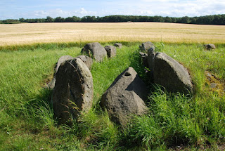
Just over the bridge on Zealand there is a 20km (12 mile) long narrow peninsula called Knudshoved Odde owned by the Rosenfeldt Estate. The ready availability of food made this a popular place in Neolithic times and they left their mark in the form of burial mounds all over the land. The estate has looked after the peninsula, protecting it from development and there are no villages, only individual houses.
A small charge is made to park on the peninsula and from Monday to Friday it is possible to drive to a car park six miles in, half way down the peninsula. We parked there and then walked three miles to the narrow causeway through the lovely countryside and views on all sides across the sea to land beyond. It was so peaceful with birdsong accompanying us all the way and cormorants passing us every few minutes. We had a picnic lunch on the other side of the causeway and then set off for the return to the van. We drove back down the dirt track to an earlier car park at the point where the asphalt road started. Here we had a cup of tea and inspected the passage grave and dolmen in the car park.
Driving back down the peninsula we took a look at the remains of two burial mounds that we had noticed on the way. We also stopped at the magnificent manor house of the Rosenfeldt Estate surrounded by huge farm buildings.
We had intended to visit the museum in Vordingborg but had enjoyed walking on Knudshoved Odde so much that we had run out of time. We returned to Sakskobing and, given that the weather was windy but otherwise lovely, warm and dry, we took another look at the town centre. We got as far as the harbour with its houseboats and yachts – very pretty.

Photos: The Rosenfeldt Manor House at the mainland end of the peninsula; One of the many Neolithic burial mounds on Knudshoved Odde; An passage grave left exposed after it had been excavated; The narrowest part of the peninsula, a causeway that leads to the last section; The restored passage grave in the first car park; Some of the houseboats in Sakskobing’s harbour.


Wednesday, 12 July 2017

Wednesday 12th July 2017 – Sakskobing, Denmark

The weather forecast for today was awful with heavy rain all day and, unfortunately, it was correct. It started to rain at about 08:00 and we have had constant heavy rain right up to now (17:30) when I am writing this blog. We had planned a ‘down day’ during our stay at Sakskobing and yesterday, looking at the forecast, we decided that today was the best day to do it. So, Jane used the campsite washing machine and tumble dryer – there was no chance of drying anything outside today! That should give us enough clean clothes for the rest of the holiday. We walked for five minutes into to the small town but the rain put us off exploring too far, the harbour will have to wait until another day. Pizza and burger restaurants are very popular in Denmark and Sakskobing is no exception. We had hoped to find a traditional Danish restaurant but settled for a pizza / burger restaurant in the main square. It was very acceptable and very reasonably priced with our main courses costing 50 DKK (£6.25) and the half litre of red wine at 65 DKK (£8.10) was not much more than I have paid for half a litre of beer in other places.
We took a quick look at the Lutheran church, built in the 13th century, which had the plainest interior of any that we have seen but still with lovely 15th century carved wooden pulpit and altarpiece.
We returned via the local supermarket for supplies and settled down for the evening. The good news is that the rain is easing and the forecast for tomorrow shows no rain.

Photo: This rather lovely fountain was very appropriate for today.

Tuesday 11th July 2017 – Sakskobing, Denmark

When we got up, the sun was shining brightly in a lovely blue sky but the forecast was that it wasn’t going to last. We were heading for the southernmost of Denmark’s major islands, Mon, Falster and Lolland. The satnav wanted us to take the motorway but there was a lovely straight road marked as a green route on our Marco Polo map so we went that way. I had spotted two barrows on the island of Mon and researched them on the Internet. Both are passage graves built about 3200 BC and are open to the public. Fortunately I managed to find on the satnav, roads with the same names as the barrows, so I was able to set up a route, which was just as well because there were no signs to them until we were very close. Both sites are well worth a visit. Kong Asgers Hoj is a single passage grave and is in a beautiful position with extensive views inland, over Stege Bay and the Baltic Sea. Klekkende Hoj is an unusual twin passage grave with a terraced mound surrounded by a platform. The construction of the passages of both sites is very impressive with massive stones on the walls and ceilings, and the gaps filled with smaller stones and crushed flint. The whole of the stone structure was covered with a layer of clay that was very effective at keeping water out of the grave. The mound was then formed with local sand and clay and they are still here over 5,000 years later. Mon is only a small island (218 sq. km.) but is known to have over 120 barrows and passage graves.
We plotted a route around Mon and, as always in Denmark, there were lots of cycle tracks and lots of cyclists but, rather than speed cyclists dressed in lycra, these were tourers travelling with all of their gear, including tents. We also saw many serious walkers, something that we haven’t seen so much in Denmark, and most of those were also carrying tents. It is certainly a very pretty island and we really enjoyed the drive. We stopped off at Elmelunde where the church, dating back to 1085 but extended and modified from 1200 to 1500, has lovely frescos dating from about 1500. The same artist who painted these frescos also painted the even more impressive ones in Fanefjord church that we visited later. In both cases, the frescos were painted over during the reformation which actually helped to preserve them. They were discovered in the 19th century and restored in the 20th and 21st centuries.
In between visits to the two churches, we drove to the far eastern end of Mon. Here is Mons Klint, famous cliffs much visited by the Danes but, after our underwhelming visit to Stevns Klint, we gave them a miss. However we did visit Liselund Slot, claimed to be the only thatched palace in the world. It is in lovely grounds, laid out with lakes, a Swiss Cottage, a Norwegian house, and a Chinese house. In the past there was also a bathhouse, a chapel, a fisherman’s house and an artificial ruined fortress. It was lovely to walk around but a light drizzle restricted our roaming.
We drove off Mon on a causeway with lots of wildlife (including an islet occupied by many cormorants) and fishing nets on either side, to the very small island of Bogo. Here we joined the motorway and the bridge to the island of Falster. Continuing on the motorway, a tunnel took us to Lolland and we were soon at our destination of Sakskobing Camping.

Photos: The view from the mound of Kong Asgers Hoj; The entrance passage of Kong Asgers Hoj, which is a T-shaped chamber; The twin entrances to Klekkende Hoj with a small boy conveniently demonstrating how low the entrance is, and it is lower for adults!; This shows the terracing and platform around the mound; The end of the Klekkende Hoj chamber; The Last Supper carving on the altar piece (1646) of Elmelunde church – note that, unusually, two of the disciples have their backs to the viewer; The thatched palace of Liselunde; The Fanefjord church dating from 1250; One of the many Fanefjord frescos – interestingly, the figures going to heaven don’t look happy but there is no horrified expression on the faces of those being led by the Devil to Hell represented by a rather Vikingesque dragon.


Monday, 10 July 2017

Monday 10th July 2017 – Koge, Denmark

We have already visited two of Harald Bluetooth’s ring fortresses at Aggersborg and Fyrkat and now we are off to visit another ring, which might be another Harald Bluetooth fort or it might not. There had been thoughts by archaeologists that there should be another ring fort in Eastern Zealand but none had been found. In 2013 a young archaeologist, Nanna Holm, from Aarhus university, studied aerial photographs of the area near Koge and found a round feature that she thought could be a fort. LIDAR showed the feature more clearly and the university called on the assistance of an archaeologist from York (ironically, as York was a Viking town) to carry out a detailed geophysical survey. This clearly indicated that the feature was very significant and likely to be a ring fort. Digging started in 2014 and will continue until 2018 and has already shown that there was a ditch and an 11m wide bank with a very high palisade (see photo) making a circle with a 123m diameter. It is estimated that it would have taken 90 mature oak trees, at least 200 years old, to make the palisade. From the analysis of the soils in the bank, it is believed that the whole structure was erected in one season, possibly within a couple of months. This is a huge task and shows the power and authority wielded by the person who ordered its construction. This may well have been Harald Bluetooth, the dates so far seem to fit but there are differences between this fort and the others that he built. Test pits made in the centre on the fort have not found evidence of the roads and buildings found in the other forts.
We joined a god number of interested Danes for guided tour and although the tour was primarily in Danish, our guide made a point of explaining everything to us in English as we moved on to the next point. When we reached the excavation, we were introduced to Nanna and her knowledge and great enthusiasm was clear to see. She made a point of talking to us in English and answered our questions. She said how excited she was about two areas of excavation that they were doing this season. Next week they are going to excavate a section of the centre of the fort and then they will know whether the roads and houses exist on this site. They are also going to excavate a large area outside the fort where, Nanna said, they may find a settlement, a cemetery or absolutely nothing! I will definitely be checking the blog on their website (www.vikingeborgen.dk) to follow what is happening. Next year they will excavate the last gate in the east where they hope to find waterlogged wood that will more accurately date the construction of the fort.
There are not a huge amount of finds from the site but some are very interesting. They found a toolbox of iron objects dated from 950 – 1050 and a piece of nondescript Stamford pottery that told an interesting tale. Stamford pottery comes from England but in this piece, the clay was Danish and the glaze was English. Nanna explained that after 1066 the Vikings in Britain went into quick decline and many headed back to Denmark, bringing skilled tradesmen with them who then continued their work in Denmark.
Wi-Fi was provided on site so that visitors could download an app on their smartphones. This allowed more information to be obtained on certain subjects and on the finds. It also has virtual reality where 3-D videos can be viewed using special glasses that attach to the phone. I haven’t tried that yet but other aspects of the app and the large number of information boards are excellent. It was interesting that on the app, boards and website, the four main archaeologists are presented almost as heroes – the Cult of the Archaeologists! This I suspect appeals to the young but Nanna told us that there is huge interest in the project from the Danish media with lots of coverage every time that a new discovery is made.
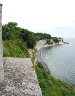
Just south of Koge is Stevns Klint – a UNESO listed area of cliffs, so we headed off to take a look. They were very pretty and, for the Danes, are quite a novelty but living in South West England, we have much more impressive cliffs and, of course, the UNESCO listed Jurassic Coast.
We returned to the campsite and walked into Koge, clutching some lovely ice creams from the kiosk across the road. Koge is a pleasant town with some nice historic buildings but it didn’t keep us for very long which was good as, just as we got back to the van, it started to rain.

Photos: From the viewing tower at the reception area there was a very good view over the site with the latest excavation area (at the north gate) clearly visible, covered with a marquee; The Cult of the Archaeologists – one of the many information boards; Nanna explaining the current excavations; Jane providing scale to demonstrate the height of palisade – it easy to image how the fort would have dominated the area; The conserved toolbox with its three sections; The cliffs of Stevns Klint; Part of Koge’s harbour – we wondered whether Danish Agro was code for ‘Viking’ with a Viking warship moored in front.