Thursday 18 October 2012

Saturday 13th October 2012 - Home


Heavy rain overnight was followed by thunderstorms this morning. The journey to Calais was extremely wet with flooded roads and water pushing off drain covers. It was still raining hard when we got to Majestic in Calais and a targeted shop saw us on the way to the port within 20 minutes. This meant that we were early enough to be offered an earlier ferry, which we gratefully accepted. The ferry was not as smart as the Pride of Britain but was comfortable enough and we were soon at Dover.
The journey back was uneventful except for the massive (10 mile?) queue on the opposite carriageway of the M25. We felt very sorry for all of those caught up in it and were very glad that it wasn't us.
Time now to plan for the next, hopefully longer, sojourn in the Spring.

Friday 12th October 2012 - Lumbres


We are never quite convinced by Michelin's 'picturesque routes' as shown on their small scale (1:1,000,000) map of France – some are fantastic and some don't seem to justify the classification. We came across both types on today's journey. The route through Evreux and on over the river Seine to Les Andelys was generally pleasant but the 'picturesque' parts were not prettier than the other and actually included a highly industrialised area. However, much later, the D316 (not the D49) from Aumale down to the A28 near Blangy-sur-Brestle was lovely. This is the valley of the river Brestle and the road, running above the river, gave lovely views of the surrounding hills and down into the many lakes in the valley.
Having missed out on a restaurant meal last night, we decided to try to find one of the many restaurants that offer midday special menus. We were approaching Formerie at the right time for lunch and headed for the town centre, parking in the main square. On the way in we noticed an hotel and restaurant that appeared to be quite popular. Walking back to it we found that the Hotel Saint Pierre was offering a €12 (£9.60), 3-course menu and the restaurant looked busy. The food was excellent and there was plenty of it – two choices for both the starter and main course and four choices for desert with the option of cheese instead. Excellent food, good portions and excellent value for money – we have noted it as a stopping point for future trips.
The morning journey was in bright sunshine but heavy showers interrupted the sunshine in the afternoon. They say that every cloud has a silver lining and we were rewarded by a succession of rainbows that painted our journey.
Arriving at the Leclerc in Lumbres we parked up in our usual position with the view over the countryside and set off to buy all of the goodies to take back to England.
Photos: The Hotel Saint Pierre in Formerie – highly recommended for its lunch menu.

Thursday 11th October 2012 - Rugles


Yesterday afternoon we saw huge cumulus clouds billowing up into the sky and, coupled with the high humidity and lack of breeze, we expected a storm. There was however no rain over night until just before the alarm went at 07:00 – just a few heavy drops to start with and then it really got going. We opened the blinds to let the lightning in and even at 09:00 this was the only light, so dark were the skies. It continued to rain for the rest of the morning, with showers in the afternoon.
We were heading back to Calais but, in our normal manner, plotted a route across country taking in any points of interest that we could find.
Crossing the Loire we left the Saumur wine area and entered the Touraine area and drove through many miles of vines where grapes were being picked in the heavy rain – not a pleasant job! Leaving Touraine we followed rivers for many miles, first the confusingly named Le Loir and then the Braye. Apart from many minor châteaux, our major target on the route was the 'Ancienne Commandarie des Templiers' at Arville. We knew nothing about it except that it was shown on the AA map as a point of interest. We arrived at lunch time and finished eating in time for the reopening of the sites at 13:30. The Knights Templar built the fortified building in the 12th century and used it as a base for the Crusades. After the Knights Templar fell out in a major fashion with the Roman Catholic church, during which many were tortured and executed in very nasty ways, the buildings were taken over by the Knights Hospitalier. We have to confess that we didn't know the difference between the two groups but it appears that the Hospitaliers were less militaristic and removed the defensive aspects of the building.
Apart from the buildings themselves, there is a museum that tells the history of the Templars. Fortunately, we were able to pay a little extra for audio guides as there were no English translations of the information boards. The Templar church was particularly interesting, being unadorned but beautifully constructed with a rounded wooden roof in the style of an upturned boat keel. The exterior of the church showed aspects of southern France and Italian architecture, influenced by sights that the Templars had seen on the Crusades.
We drove up through the national park 'Parc Naturel Regional du Perche' just to the east of Nogent-le-Rotrou but, apart from the preponderance of manor houses shown on the map, didn't find it any more beautiful than the very pretty landscape that we have driven through in the morning.
North then to Rugles where we stopped at an aire marked in our 'All the Aires of France' book with an asterisk denoting “a very nice site”. It is in a pleasant position but no more so than many others that we have stayed at. However it does have free electricity, which was very useful.
The aires book also said that there were many restaurants in the town and we had decided to have a last meal out in France before the end of the holiday. We walked into the town past two old watermills and toured the town looking for restaurants. We found one closed restaurant, a 'restaurant snack' that we didn't fancy and a pizza restaurant, which looked pleasant but didn't serve the French food that we wanted. We returned to the van to have Cassoulet a la Tin followed by a gorgeous crème brulee that we bought from a bakers in the town.
Photos: The Templar's building in Arville; We didn't have time to stop for the night but decided to check that all was well at our French second home (the 16th Century Manoir de la Moussetiere); Rugles very close to the aire with the water mill on the right and the town's public washing place ('Lavoir') on the left.


Wednesday 10th October 2012 - Turquant


We headed back to the Loire valley today but planned to call in at a couple of sites shown on the AA map. However, there were no road signs to the dolmen that we were looking for and likewise there were no signs to the 'Pigeonnier Souterrain' (an underground pigeon coup – I kid you not!), so we carried on north.
After two 'Route Barree' (closed roads – the French have loads of them!) and one that should have been closed (we had to squeeze between a ditch and an aggregate lorry after a long wait), we arrived at the Loire past large vineyards of the Saumur region. We drove along to the small village of Turquant famous for its wine, mushrooms, dried apples, tufa stone and troglodytic houses and took the last place in the aire. The tufa stone, a free limestone, is very soft, easy to extract and easy to carve. It makes an excellent building stone and was mined in the 11th and 12th centuries from the cliffs along the edge of the river. This left holes that were ideal for habitation and, given that the area was unstable, it provided a safe and free place to live. In fact, it was possible to extract the stone and sell it whilst building your house. Later, as the area became safer, the residents started building houses outside the caves but still leaving the caves as part of their homes. Many of these semi-troglodytic houses still exist and we saw a selection of them as we took a marked walk around the village. The walk also included long views north over the Loire and many wine producers with signs offering tasting and sales. Having seen grapes being mechanically picked earlier in the day, here we saw them being picked by hand and the smell of fermentation hung over the village.
The village caves are also used for the production and storage of wine, the growing of mushrooms (producing 1,000 tonnes a month in 30 kilometres of the ex-quarry tunnels) and for drying apples, a traditional activity now only done for the tourists as the caves are open to the public.
Jane discovered signs for a free WiFi hotspot in a small tourist information room attached to the Mairie (mayor's house) – the first opportunity for WiFi that we had found this holiday. Unfortunately, when I took the computer over there was no sign of the wireless network.
Photos: The Welcome to Turquant stresses the wine producing and just to the right (out of shot) was a stone mason producing fireplaces from the local tufa rock; One of the wine producers based in the cave – wine production was in full swing inside; A semi-troglodytic dwelling; There has been a distinct lack of wildlife in my photographs this holiday – Jane discovered this specimen when we went for a short walk late in the evening. We then nearly stood on a tiny frog hopping along the pavement. The rest of the walk was spent looking down, watching our feet!


Tuesday 9th October 2012 - Vasle


The weather has been very unsettled over the past few days, warm, especially at night, with a mixture of light rain, sharp showers and bright, hot sunshine. Last night was especially warm with the outside temperature at 07:00 this morning, just before dawn, being 17°C.
We arrived at the Tumulus of Bourgon at 10:00 when it opened and started our visit by walking to the collection of five tumuli. On the way we passed excellent installations showing the latest ideas as to how the tumuli were constructed. Four stages had been reconstructed showing the placing of the initial stones for the wall of the burial chamber; placing the large capstone on the chamber; the completed tumulus prior to it being covered by the mound; the dolmen of today – the tumulus after the effects of erosion and human activity over the millennia.
We then passed a reconstruction of an enormous 3rd millennium BC communal thatched building before we arrived at the cemetery. The tumuli were intriguing – different shapes and sizes, reused in different periods and then there was an enigmatic low bank (a tumulus without burials?) that separated the cemetery into two parts. It was possible to enter the burial chambers of most of the tumuli – some had more than one. The tumuli date from approx. 4700 to 3500 BC, a period of nearly 2,000 years. This makes it one of the most ancient and important example of funerary architecture in the world.
Many tumuli in England were plundered in Victorian times when it became fashionable for land owners to take their family and friends to these ancient cemeteries and, while the family enjoyed a picnic, the workers dug down through the centre of the tumuli to find the burial at the centre. This was generally done in a very unscientific manner, so no records were kept and the finds lost. At Bourgon however it was different. Initially investigated by interested amateurs in 1840, it was purchased by the local authority in 1873 to ensure that it was protected for the future. They have done a very good job!
On the way back to the museum we passed an installation showing ideas of how megaliths were moved by the ancients. Experimental archaeology was performed using a 32 tonne block and logs. It took 200 people to pull the bock over the logs but when levers were used to turn the logs under the block (there is no evidence that the ancients used this technique), they were able to move the block with just 15 people.
We had been provided with an English language audio guide that was extremely useful as we went around the external exhibits and it also covered the museum exhibits. There were extensive exhibits on general prehistoric archaeology, specific sites in France and world-wide, films (our audio guide gave us real-time translations to the commentary), and finds from the Bourgon site. It was very good, the only niggle being that there was very little audio commentary about the Bourgon finds.
We had spent nearly three hours at Bourgon and were very glad that we had decided to come back today.
We drove on to the ravine that we intended to visit yesterday, Puits d'Enfer (The Well of Hell). When we arrived at this popular beauty spot it started to pour with rain – we decided that we weren't that keen to see a small waterfall in a gorge!
Next on the list was the Gallo-Roman remains near Sanxay (Ruines Gallo-Roman d'Herbord). An umbrella was required as it was drizzling at times but we went to inspect the theatre, baths and temple. We have seen a few Roman theatres and this one was fairly run-of-the-mill but the baths and temple were impressive. We found out later from the curator that this is one of the best preserved Roman bathhouses in France. Walls stood to a great height and it was easy to see the construction of the different pools – Roman concrete supported remnants of the flooring that clearly showed the imprint of the tiles that lined the pools. In the hot pools, this floor was suspended 1.5 metres above the ground surface. This is where columns would have supported the pool allowing the hot air from the furnaces to circulate and heat the water above.
The temple complex consists of a large open area surrounded by a colonnaded terrace and with a 1st Century BC temple at its centre. This is of Celtic design and is thought to have been built over an earlier Gaulish shrine. Four arms protrude from the octagonal centre below which there is a sacred spring. The Romans adopted the site (they liked to convert existing religious sites) and dedicated the temple to Apollo and Mercury. It appears to have become an important site for the Romans who came to be cured by its therapeutic waters.
Jane had spotted an aire in the 'All the Aires of France' book that said Vasles was a “sheep village; lots of items celebrating sheep”. We were both intrigued by this and many miles away we saw road signs directing the way to 'Vasles – Mouton Village'. We decided to make that our overnight stop.
I must say that it was disappointing. The aire was good but the town is uninteresting unless you want to visit the Mouton Village that has sheep from all around the world, including Scotland but, strangely, not Wales.
Photos: Bourgon - Building a tumulus, here showing how the walls of the burial chamber were constructed; Tumulus F at Bourgon that has three separate burial chambers; Inside the burial chamber of Tumulus A; The Roman Temple at Sanxay.


Monday 8th October 2012 - Pamproux


We thought about going into Poitiers today but decided to leave that for another year. Vivonne is an excellent location to visit Poitiers by public transport as there is a main TGV railway line and a good bus service into the town. The railway station, where the buses also stop, is just 200 metres from the motorhome aire.
When touring, it is important to keep an open mind. We plan roughly what we are going to do that day but are always willing to change our mind. Today was one of those days where we ending up doing none of what we had planned.
We set off west from Vivonne heading for a ravine shown as a point of interest on the AA map but came across a tourist sign to the Tumulus of Bourgon. We had seen this on the map but hadn't noticed that there was also a museum. On a whim, I turned off the main road and followed the signs. Monday is the day when many museums and sites are closed and many sites are not open in low season. Sure enough, the museum was closed but we had a look at the outside and that was enough to convince us that this was a major site and well worth a visit. Establishing that it was open tomorrow, we decided that we would return in the morning. Now we had to decide what we were going to do for the rest of the day.
There are ancient silver mines in Melle and, given that we were now not far away, we decided to investigate. We arrived to find two coaches of school children there – it was open! However, it turned out that it was only open for schools during the week at this time of the year and we couldn't wait until the weekend to see it. We headed out to the abbey at Celles-sur-Belle when Jane had noticed that there was an aire where we could have lunch.
The aire is in a fantastic position next to the very attractive abbey. We met another British couple there – Eli and Maureen were on their way to Spain for six months and we stood chatting with them in the hot sun for ages until we decided that we really had to investigate the village. It was possible to walk around the grounds of the abbey where there was a huge and intriguing 'Insect Garden'. The abbey church was lovely with a simple interior and elegant columns towering up to the roof.
We pottered back to Pamproux, close to the Tumulus of Bougon and found the aire on the edge of the village. It seemed like a peaceful location but then the lorries started driving past. Half of the French army were being transported past our aire. When I checked our map, I found a military area just east of the village and, judging by how quickly the lorries were turned around, that was their destination. Fortunately, the lorries stopped by about 22:00 and we were able to get a good night's sleep.
Photos: The Celles-sur-Belle abbey and the lovely doorway and soaring columns of the abbey church.


Sunday 7th October 2012 - Vivonne


We were off early to walk to the banks of the Loire where we joined many other people at the very large market. The market is held on Fridays and Sundays and is well worth a visit. Everything is there, from plants to ironmongery, double-glazing to clothes and, of course, large number of food stalls covering meat, fish, shellfish (including Breton mussels and oysters), cheese and vegetables. My favourite was the bread stall exhibiting beautiful breads cooked in a wood-fired oven. We were modest in our purchases – four saucissons, a French salami (I chose duck, wild mushroom, smoked and choriso); a wooden pestle to replace my broken one and one of those lovely loaves.
Jane had taken a fancy to the area around Poitiers and the AA France map showed some interesting historical and archaeological sites there so we set off across country. The Amboise aire has no water or dumping facilities so our first port of call was the aire at Athee-sur-Cher where we were able to fill our fresh water tank and empty our waste water.
There were scattered vineyards in the gently rolling countryside on most of our journey but not the vaste areas that we have seen in the major wine-producing areas. There were many very small ones, perhaps only four or five rows of vines alongside large fields of sunflowers or maize, obviously these were the farmers personal vines.
We arrived at the very pretty river La Vienne and drove south alongside it, passing the impressive Château de Tauffou on the opposite bank, until we crossed the river to the village of Civaux. The map showed a Gallo-Roman Cemetery here, what it didn't show was that it was in the shadow of the enormous cooling towers of an EDF power station. The cemetery however was well worth the visit. Stone flags formed the perimeter and inside were hundreds of sarcophagi, half-burried, laying on the surface or propped up against the walls. It soon became clear that the stone wall was actually made entirely of the lids of sarcophagi. The cemetery started life in Roman times and continued to be used after the Roman times, right up to current times with the latest inscription that we saw dating to 2012. Some of the sarcophagi have been dated to the 6th to 8th century AD and some have re-used ancient (Roman?) columns and stele (gravestones). Fascinating – we have certainly never seen anything like it before.
Travelling west, we came to Château-Larcher were the map marked a Lanterne des Morts (a lantern of the dead). The map showed a number of these from here to the coast and we were intrigued to find out what they were. Following signs, we passed the Mediaeval château that gave the village its name. Houses have been built against the extant parts of the castle whilst other parts are in ruins. The castle chapel was turned into the village church in the 12th Century with a new, impressive entrance created in the castle walls. We were able to park a few metres further on and walk to the cemetery where we found the elegant, slim structure of the Lanterne des Morts. Fortunately, an extensive information board was attached to the cemetery gates and, with our limited grasp of French, we were able to establish that there are 30 such structures in the area and that they were built in the 10th Century. The Château-Larcher Lanterne des Morts is a particularly good example in excellent condition. A lamp was put into the hollow structure through a door at the base and this produced a light through the openings at the top.
On then to Vivonne and the aire in the centre of the village next to the Tourist Information Office.
Photos: The Amboise market – bread cooked in a wood-fired oven; The cemetery in Civaux – the wall that surrounds the cemetery is made entirely of the lids of the ancient sarcophagi; The Lanterne des Morts at rench -Larcher.


Saturday 6th October 2012 - Amboise


A bit cloudier this morning but warm and pleasant so we set off to do the other two walks around Amboise. The first one concentrated on the architecture of the town whilst the second took us to Troglodyte houses and above the chateau to the high land favoured by the Gallic tribes and the Romans although only scant remains of both survive.
As we arrived back at Henrietta for lunch, a gentle drizzle started – excellent timing! We decided to stay on to see the big market here tomorrow morning so we settled down to a quiet afternoon catching up with chores, writing blog, watching the rain and reading. Dinner was 'Confit du Canard au Legumes et Cidre' (duck legs roasted on a bed of vegetables and cider) at Chez Henrietta.
Photos: Detail of a sculpture in Saint-Denis church in the centre of Amboise; A Troglodyte house in Amboise, once used for the production and storing of wine but now available for rent as a Chambres d'Hote.


Friday 5th October 2012 - Amboise


The minor road next to the aire is relatively quiet but as everyone has to park very close to the road, the aire can be a little noisy. The owls, both tawny and barn, were also quite noisy but we didn't object to that.
There was gentle rain again at night but the sun was soon shining and we drove on to Amboise, a town set on the banks of the Loire. On route was a Leclerc hypermarket where we were able to stock up with food, fuel and, most importantly LPG gas that we, quite correctly, decided must be getting low.
Having parked in the Amboise aire, we walked for a few minutes into town, our first stop being the tourist information office. They provide three excellent walk leaflets in English that guide you on three different walks around the town. We started with the 'Reflections on the Loire heritage' leaflet and this took us across the bridge to Ile D'Or, an island in the middle of the Loire, and then on across another bridge to the north bank of the river. The information in the leaflet was excellent and it was sobering to see the extent of the flood defences, breeched in 1856 by a huge flood that saw the Loire reach a height of over 8 metres.
In the evening we walked into town to have dinner in the Parvis restaurant with a lovely old-world atmosphere and a wood-fired grill. The English translation of the menu was interesting, with two of my choices being shown as 'Rump Steak Wipes in the Choices' (rump steak with a choice of sauces) and 'Rice Pudding in the Toffy Butters Salted House' (rice pudding with caramel sauce). It was a lovely meal and I can thoroughly recommend the restaurant.
Photos: Traditional boats used to transport goods on the Loire – it is possible to go on trips on these or spend a cosy night on board a slightly larger version with a small cabin; View of Amboise and its Château from the bridge over the Loire; Jane getting up close and personal with Leonardo da Vinci represented as an ancient god – Leonardo stayed here for a few years whilst working for Francis I and may have had a hand in the design of Château Chambord. He died in Amboise and may be buried in its château.


Thursday 4th October 2012 - Ouchamps


The weather for the last few days has been unsettled with some rain at night and, during the day, a mixture of bright sunlight and occasional drizzle but not enough rain to stop us doing anything. Yesterday evening we had a heavy shower and more rain during the night. We woke to leaden skies and it was soon raining, looking set in for the day. We weren't in a hurry to get going but when we did we were surprised to see the heavy cloud moving away to be replaced with blue skies and sun.
We drove to Bracieux to check out a campsite, one of the very few that are open after the end of September, and finding that it looked very pleasant, noted it as a potential place to stop tonight.
A few miles further on we arrived at the magnificent Château of Chambord, the largest and most visited château in the Loire valley. We were still in the La Solonge area and has passed more lakes and signs warning of those elusive deer and wild board. We passed another such sign as we entered the walled royal estate of Chambord, an area of 54 square kilometres, the largest hunting estate in Europe. Jane was just saying “I can't see any ...” when she said “Yes I can” and pointed to a family of wild boar, two adults and one young. The vast majority of the estate is a 'no stopping, no walking' area reserved solely for the use of high-ranking members of the French Government. However, this is great news for the wildlife (apart from when they are being shot!) and they thrive in the reserve. We slowed down but had to content ourselves with a brief view of the wild boar.
As you can see from the photograph, the château is a very attractive building with a wonderfully ornate roof area. At the age of 25, King Francis I initiated the project of building the château in 1519 but when he died in 1547, having only spent a total of 72 days there, it was not completed. By this time, only the keep and the royal wing had been built. Francis used Chambord as a very sophisticated hunting lodge and only stayed for a few days at a time whilst hunting in the park. He apparently found it cold and draughty in the Winter and as it was surrounded by marsh, mosquito-infested in the Summer. The château has had a chequered history with periods of neglect interspersed with periods of building and improvement. Over the centuries, the marshes were drained, a curtain wall built and many more rooms and embellishments added. It is now 156 metres long, 56 metres tall, has 77 staircases, 282 fireplaces and 426 rooms!
We spent about 3 hours wandering around the interior the highlights being the double spiral staircases in the centre of the keep and the views of the magnificently carved roof structures from the balcony.
There are 10 square kilometres of the estate are open to the public and are freely accessible at any time. We had obtained a map of walking routes from the information desk by the car park and, given that the weather was still sunny and warm, we set off into the woods to search for deer and boar. Immediately we saw many signs of boar with disturbed ground everywhere but we did not catch sight of any animals even from the observation towers. To be fair, the time to see them is really at dawn and dusk, especially the deer at this time of year when it is rutting season. The walk was however very pleasant although some confusion was caused by the green and blue routes on the map being reversed by the the route markers on the trees. One of the people responsible was obviously green / blue colour-blind.
We had contemplated staying the night in the aire at Chambord but felt that the additional €20 fee was a little steep given that there are no shower or toilet facilities. Instead we just paid the €6 parking fee (this could be avoided by parking in the forest car parks and walking in) and headed off to the aire at Blois.
We normally try to arrive at our next stop by 17:00 but it was gone 18:00 when we arrived at Blois to find that the aire no longer exists. There were no signs to the aire and there was no sign of motorhomes parked where our book suggested that it should be. A reappraisal of our options was undertaken and we drove on about 9 miles to Ouchamps where we found the aire by a lake on the edge of the village.
Photos: Château Chambord; Roof detail; The double-spiral staircase at the centre of the keep.


Wednesday 3rd October 2012 - La Ferte-Beauharnais


Yesterday we started having second thoughts about our itinerary for the rest of the holiday. We had intended heading south down the Loire to its source and then heading over to the Rhone valley. However the journey so far had been slower than anticipated because we had found so many places of interest on the way. We decided to review the situation!
We drove on to the aire at St. Brisson-sur-Loire, a short distance south of Gien and on the opposite side of the river. After looking around the interesting village, we sat in Henrietta with maps spread over the table and guidebooks in hand. In the end, it was a unanimous decision to head west rather than south and stay close to the Loire.
The journey took us through La Solonge, an area of forest, mash and lakes that is very popular with French visitors. It is a very important hunting, shooting and fishing area with signs on the road warning that deer and wild boar are likely to jump out at any moment. Unfortunately, not a single wild boar did we see – we have seen lots of deer before, but we didn't see any of those either. However it was a very pleasant drive with lots of lakes and heather-strewn forest floor. We passed a number of aires, including a tempting one by a lake on the edge of the large town of Lamotte-Beuvron and finally weakened when we got to La Ferte-Beauharnais and parked up at the aire next to the small lake on the edge of the village.
We walked around the village with its interesting architecture – old wood-framed buildings that look as though they needed a lot of attention.
Photos: Jane inspects a potential second home in St. Brisson-sur-Loire but we might need my mate Les to help with the building work!; The Trois Canard (Three Ducks) bar in La Ferte-Beauharnais next to one of those houses in need of some tender loving care!


Tuesday 2nd October 2012 - Gien


We have recently bought a new map of France and after some research, we chose the spiral bound AA Big Easy Read 1:190,000 map. We chose it because it was easy to read, easy to handle with the spiral binding but most of all because of the detail of sites of interest, especially historic and archaeological sites. It really is excellent for locating Roman remains and pre-historic sites such as dolmen. We noticed that a few miles east of Bray was an area with a number of dolmen, so we took a small diversion. Sure enough, we found some signposted from the road and we were able to visit them. We then moved on past the ancient abbey farm of Vauluisant, paused at the Devil's Rocks picnic site for a coffee and then stopped at Villeneuve-sur-Yonne to wander through the town. The Yonne is yet another major river in this area that has barges plying up and down it and the town was walled, although only two very impressive gatehouses remain of the fortifications.
We made a quick visit to the Roman amphitheatre of Chenevieres before pushing on to the aire at Gien. We had inspected the aire previously, stopping for lunch, but haven't stayed there. It is on the banks of the river with a pleasant walk along the riverside to the town – a walk that we followed to find a small restaurant for our evening meal.
Photos: The Dolmen des Blancs Fosses; Vauluisant Abbey Farm.


Monday 1st October 2012 – Bray sur Seine

On our walk yesterday we came across the Musee des Pays de Seine et Marne, a museum of rural life and, noting that it was open today, we decided to pay it a visit. The museum's aim is to inform the visitor about the traditional rural and industrial life of the area and it does it very well. Exhibits of farming practices and the crafts of cheese making and basket weaving reminded us very much of Somerset and our own Rural Life Museum in Glastonbury. Many other crafts were covered such as the production of spirits (with a mobile still on display), vine growing, sheep and cattle rearing and weaving with a magnificent loom dominating the room. Most impressive was the way that the exhibits were displayed, with excellent lighting and a very open and clear feel to the room despite the number of artefacts. One area of particular interest to me was the millstones. We had noticed a large number of millstones around the village and it turned out that the area around the nearby village of La Ferte-sous-Jouarre was a major source of millstone grit. There were many quarries in the area producing millstones for wind and water mills and these were exported all around the world, with many British mills using French stones. The visit was made much more interesting by the booklet in English that gave us a guide to the museum as a whole and a translation of the descriptions of the individual artefacts.
We moved on, determined to get to the Mediaeval walled town of Provins. The satnav took us on a rather strange route that had the happy side-effect of taking us to a free parking place next to the Porte de Jouy, the 13th Century gate to the town. Visitors are not allowed access to the town from Spring to Autumn but the locals obviously are as there were plenty of cars around. The town is well worth a visit and walking around the Mediaeval streets is a delight. One intriguing find was the very large Mediaeval farm buildings still in use in the centre and that explained why an enormous tracked tractor was manoeuvring its way out of the Porte de Jouy as we were walking in. This obviously dated back to Mediaeval times when the surrounding land was farmed during the day whilst the farm workers retreated to the safety of the wall town during the night or times of unrest.
We also walked down into the more modern town below. This was a classic case of a town expanding into less suitable areas. The land here was marshy and this has caused problems with the churches and other large buildings, many of them suffering from serious subsidence.
We thought of staying in the aire at Provins but as we had time we decided to move on to the aire at Bray sur Seine. There is a car park and motorhome services right on the quay but the aire is 200m further on next to a pretty park. We were able to watch sand and aggregate being loaded onto a barge before it set off on its journey down the Seine.
Photos: The Musee des Pays de Seine et Marne; A Mediaeval building on the corner of the Place de Chatel in Provin; Aggregate barges on the Seine at Bray.


Sunday 30th September 2012 – St. Cyr sur Morin


A cold morning was compensated by clear blue skies and we had a very relaxed start, taking advantage of the campsite showers before breakfasting on croissants.
We drove the short distance to Orrouy, due south of Compiegne. A walks leaflet from Pierrefonds tourist information told us that there was a walk there that took in some Roman ruins, however there was no map or details of the route. When we arrived at Orrouy we had to follow a short diversion as there was a flea market in full swing. We found somewhere to park and headed back to the flea market to find that there were also children's rides and a penny arcade and all this in a very small village. Resisting all of the temptations (it was too early for sausage and chips), we decided to set off on the walk. Fortunately, Jane spotted a board with a map showing the route of a walk from the village that also included the Roman ruins. It was a little longer than we wanted so we cut off part of the walk by taking a quiet road. Climbing up a hill we arrived at level open ground with large open field of beet. Arriving at the Roman ruins of Champlieu we found an impressive theatre, a bath house and a temple. The theatre would have held many hundreds of spectators and we had to wonder where the rest of the population had lived – they must have been close.
The remainder of the walk was through forest currently being thinned and the felled trees taken for timber and firewood.
We arrived back at the motorhome and headed off, stopping in a lay-by for a very late lunch. Once again, we decided that we wouldn't push on to Provins, so we headed for an aire at St. Cyr sur Morin. The village is small and pretty and the aire is between the Little Morin river and a mill leat. Mills were obviously important in the area with two extant mills on the outskirts and millstones on display in many places. We had a pleasant wander around the village and bought some food at the local shop, open at 18:00 on a Sunday, a rarity in France.
Photos: The Orrouy portaloo, so much nicer than those modern plastic ones!; The Champlieu Roman theatre; Taking another step back in time, this fuel pump in the village of Champlieu is still in use.


Saturday 29th September 2012 – Pierrefonds, Northern France


We had a clear plan for today – a walk in a forest, visiting a chapel and Roman remains followed by a Mediaeval town. We drove south from Attichy and as we came down the hill into Pierrefonds our plans changed as we both let out an involuntary “Wow!”. Laid out in front of us and dominating the town was the most fantastic castle. Fantastic is the right word because it looks like something out of a fairy tale.
We followed signs to a car park that had a view over a lake to the château and walked down into the town. We found the Tourist Information Office that had a sign saying that it opened at 10:00. However, this is laid-back France and it was 10:00 before a lady arrived to open up. We obtained a town walk leaflet (disappointingly lacking in historical information) and asked about camping. We were told that the Pierrefonds municipal campsite was closed and the nearest campsite was the municipal campsite in Attichy – the one that we parked by last night.
We walked up to the castle, admiring the huge walls and the turrets towering above us and bought tickets at the office (€7.50 each). We then walked in the imposing entrance over the drawbridge and under the portcullis with the murder holes above.
The castle is actually quite modern, built in the mid 1800's by Napoleon III over the ruins of a 14th Century castle that was destroyed, after a siege in 1616, by Louis XIII. Napoleon III was influenced by the growing interest in romantic ruins in the 19th Century and he commissioned the architect Viollet-le-Duc to restore the château as an occasional residence. A second home like no other!
There are some lovely decorated rooms and there are intriguing stone carvings, especially in the courtyard. You also get to see some of the defensive parts of the castle with arrow slits and murder holes. The size of the rooms and solidity of the building are quite awesome. The only disappointment is the number of areas that are off-limits especially some of the higher towers. In the grounds (no ticket required) are a number of massive replica catapults of the type that would have been used in Mediaeval times.
Walking back down into the town we found a restaurant with tables next to the lake and sat in the sun sipping glasses of cider. Jane had her favourite French dish – Gallette, a pancake in this case stuffed with ham, cheese, mushrooms and cream. I find it difficult to visit France without having Moules Frites (mussels and chips) at least once, so I decided to have my fix early just in case I don't see it on a menu later.
We decided to combine parts of the Town Trail with the Country Trail and set off round the town before heading into the forest. A combination of a very poor map and our very poor French meant that we went slightly off the route but this turned out to be fortuitous. We arrived at the municipal campsite to find it looking distinctly open despite having been told that it was closed. When we enquired, we discovered that it was open for one more night – just what we needed.
We found our way back to the correct path and after emerging from the forest we enjoyed a lovely view of the château seemingly surrounded by forest. We also passed a large stag with huge antlers on the edge of the forest and noticed from a information board that they are to be found wild in the area. However this one was either domesticated or had been tamed by the local people as it seemed quite at ease next to house with people and a dog in the garden.
Returning to the car park we drove round to the campsite and found a pitch bathed in late-afternoon sunshine.
Photos: The Pierrefonds Château – a view from the walk; The Dressing Room with its en-suite facilities in the corner; Detail of painted stone carving above one of the many fireplaces.


Wednesday 17 October 2012

Friday 28th September 2012 – Attichy, Northern France


Despite the fact that the store doesn't open until 08:00, the muzak is switched on at 07:00 when the staff start to arrive. I have thought that the staff may have demanded that the music is played all of the time that they are at work but, given that they can't be that mad, I have decided that they switch it on when they arrive to make sure that they don't forget later. Anyway we wake up to the gentle, if inane, background muzak and switch on BBC Radio 4 (Long Wave) to drown it out.
After breakfasting on lovely, buttery croissant, we topped up the water tank and set off. As always, we try to avoid motorways and major roads, preferring the excellent and deserted minor roads. This journey did not disappoint. There had been rain overnight but we were blessed with sunshine and excellent visibility as we travelled through lovely countryside and pretty villages. This area saw a great deal of fighting and death during the First World War and the fields and villages are littered with war cemeteries. We found a British War Cemetery at Ecoivres and stopped to take a look. There were many graves of Portland stone marking the graves of Commonwealth soldiers (British, Canadian, Australian and South African) but the cemetery was originally used by the French and many stone crosses marked their graves. There were also four graves of German soldiers but we were unable to find them.
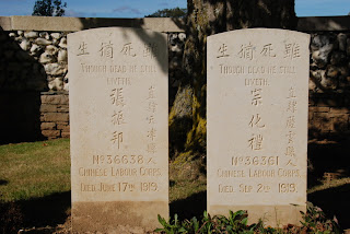
A little further on we saw a sign to a Chinese and Indian War Cemetery at Ayette and were intrigued as we hadn't even seen Chinese or Indian WWI graves. The Indians were labourers, drivers or in the Central Indian Horse but the Chinese were all in the Chinese Labour Corps. The surprising thing about the Chinese graves were that most of them died after the war had ended, mostly in 1919 and one as late as September. Why all so late? I have made a mental note to investigate further when I have access to the Internet. The inscriptions on the graves were also most unusual - “A good reputation endures for ever”, “Faithful unto death”, “A noble duty bravely done”.
We got distracted on the way and changed our plans on a number of occasions. Looking at the map we spotted the Clairiere de l'Armistice just off our intended route and decided to pay it a visit. It was here that the armistice was signed at the 11th hour on the 11th day of November 1918 in a railway carriage to end World War I and where Hitler insisted that France signed their surrender, in the same railway carriage, in 1940. We visited the museum here and saw an identical railway carriage fitted with the original furniture from 1918 – the original carriage displayed in Berlin was destroyed on Hitler's orders at the end of WWII because he wanted to prevent it from being used by the Allies for Germany's surrender. The museum has many souvenirs of WWI and an incredible collection of stereoscopic images of the war. Well worth the €5 entry fee.
It was only a short drive to Attichy to the aire, a car park outside the swimming pool, next to a very pretty lake. A lovely position for the night.
Photos: Two Chinese graves in the Ayette Cemetery – note the dates; View over the lake at the Attichy aire.


Thursday 27th September 2012 – Lumbres, Northern France


Events at home conspired against our normal two-month sojourn and we have had to console ourselves with just a 16-day break. We really wanted to have a break abroad and therefore chose France as it is only a quick trip across the channel.
Leaving home before 09:00 we drove to the campsite where we store Henrietta (our Hobby motorhome), did the final packing and by twenty past nine we were on the road. We had booked the 13:55 P&O crossing from Dover to Calais and found ourselves on the Pride of Britain. The initial impression from the dock was that it was much larger than other Dover ferries that we had used and when we boarded we were very impressed. The ship entered service only last year and is very spacious and comfortable and we were particularly impressed by the open area at the stern. Sat on chairs eating our lunch we enjoyed the warmth of unbroken sunshine whilst admiring the views of France forward and the cliffs of Dover receding behind us. Dover-bound ferries passed us (including the sister ship, the Pride of France) whilst all manner of ships, including those massive, seemingly top-heavy, container ships were plying the English Channel.
We seemed to arrive in Calais in no time and were soon heading for the Majestic Wine outlet. Here we sampled a few wines and bought a few others to try over the next two weeks with the idea of calling in on the way back.
We then drove on to Lumbres where we stopped at the Leclerc Hypermarket. We have used the aire here on a number of occasions as it provides a good, free stopover close to Calais. More to the point it is an excellent place to pick up lots of French goodies either for the holiday or to take back home.
We are all used to the muzak played in shops but the Leclerc here takes this to a new level. We park by the side of the store so that we can see the lovely view over many miles of the surrounding countryside and here they have speakers that broadcast the muzak to the car park! Fortunately, it is not a 24-hour store and the speakers are turned off when the store closes at 20:00.
Photos: Leaving Dover behind.